Posts

7/30/25 W6/SC-357 (Cerro San Luis Obispo)

Image
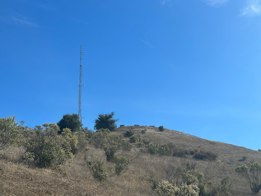
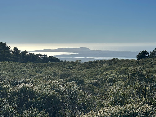
I was on a business trip to San Luis Obispo and feeling like taking a morning hike, so I picked Cerro San Luis Obispo.  I'm trying to get myself back in shape and I figured this one was going to be challenging, but not too much so. After studying the routes I decided to park at the Marsh/101 trail head and take the route from the east.  It was mostly the "M" trail. As you can see, the "M" trail is quite clearly marked with a giant "M" on the side of the hill that I'm sure you can see for miles. Gaia GPS has a new feature that gives you trail elevation and difficulty, so I knew I'd have a little bit of trouble on the far east side once I got up to about 800 feet and made the westward turn. The trail was fairly uneventful until I missed that turn because I didn't even see the trail.  If you take this route and get to this bridge, you've already passed the trail about 100 feet back. It got a little challenging from there.  The trail was na...

11-9-24 W6/NC-401 (1140)

Image
On a family trip to Fort Bragg I found a quick one point summit about 20 minutes away from our AirBNB, so I took the opportunity to do the activation.  I only had the van with me so I had to worry about low clearance and thin tires, but I figured if I had to hike it all the way from Hwy 20 I'd still be okay, as it looked to be less than a mile from the main road. This summit had only been activated 4 times previously, so I was a little worried about access. This summit is inside the Jackson Demonstration State Forest so I expected fire roads.  Heading south on 20 there were two fire roads on the map that could lead to the summit.  I took the one to the north.  It was paved and in great shape even for its age, and there wasn't a gate.  About a half mile or so up, you take a right jog on a dirt road, but even that was in good shape. The van made it quite easily even though I had to pull over in a tight spot to let a logging truck by.  I had loaded the AZ into...

11-3-24 W6/NC-150 (Black Mountain)

Image
I was heading up to Black Mountain to install a point to point link for a local radio station, and got to drive all the way to the top.  So I threw my SOTA bag in the car hoping I'd have a few minutes to activate.  We drove up Page Mill Rd and took a left into the combination-locked gate, went through a padlocked one, and then ended up at site 5 to do our work. The tower we were working on was outside the activation zone, but that wasn't anything a 5 minute hike couldn't fix.  SOTAGoat to the rescue, and I found a nice tree just inside the activation zone to throw my wire into.  Tuned up on 18 Mhz and got about 7 contacts, then had a couple of minutes to move over to 40 meters for another 2. It was a quick one and sorry I didn't try any other bands, but I had people waiting to drive back down. It sure beat the 3 hour hike the last time I did this peak!

11-10-23 W6/NC-221 (China Grade Benchmark)

Image
  I did this one after activating Ben Lomond Mountain.  It was maybe an hour away down some fairly windy one lane paved roads. But it was midnight GMT so technically a different day. This summit is literally along the road to Cutter Scout Reservation, where've I've been to a number of times before it was burned to the ground in the fires a few years ago.  There is a locked gate just a few hundred feet past the summit, but it's accessible.  A parking turn out was maybe 80 feet down the road. The summit itself towers about 50 feet above the road, and there's some deer trails that seem to go to the top, but when I pulled my phone out and noticed the AZ extended to the road, plus it was going to be dark in an hour, I decided not to hike up.  There was a very nice rock right at the gate that made a perfect chair, so I decided to set up just inside the gate. There were a couple of tall emergency cones on either side of the gate, one of which made a perfect place to st...

11-9-23 W6/NC-178 (Ben Lomond Mountain)

Image
  On may way home from a client call in Santa Cruz I took a last minute unplanned detour up to Ben Lomond Mountain.  The area was extremely fire damaged a few years ago, and while a lot of that damage still remains it no longer looks like a total war zone, and is open for normal traffic.  I've gotten into the habit of throwing my SOTA go bag in the car whenever I leave San Jose, just in case. The AZ is a very long path along the road, maybe even a mile, so you can setup on the side of the road just about anywhere.  The actual summit is inside a government training facility that is right next to a county incarceration center of some sort. I've seen past posts that indicate it is a CalFire station but I didn't see any indication that was so. Due to the barb wire fence and keep out signs, I decided not to set up in the parking lot like previous posts mentioned.  I drove down the road just a bit and found a large turn out right next to some antennas, checked SOTAGoa...

11-2-23 W6/NC-399 (Coyote Peak)

Image
  I decided to go for a hike at lunch today, and the trailhead for Coyote Peak is a few blocks from my office, so I grabbed my SOTA kit and took off.  I've done this peak already a couple of times, the last time being just after I recovered from Covid and I remember it wasn't very fun, with all the respiratory issues I was having at the time.  I was hoping today would be easier. Just after entering the park, there is a kiosk to pay the $6 day use fee.  The automation station only takes credit cards and not cash. There's no permit required, but if you don't have the parking ticket on your dashboard you'll get an expensive ticket. I know they weren't charging during the pandemic, but that's over now. I parked in the main lot.  The trailhead here heads up to the Bay Area Ridge Trail.  Right at the start is a supply of paper maps. I'd suggest taking one if you've never been on these trails before, and then returning it when you're done with it.  They...

10-27-23 W6/CC-071 (Point Reyes Hill)

Image
  I went on a family trip to the Point Reyes area and was able to get away for a couple of hours to activate what looked like a drive up summit, or close to it.  Our cottages were a couple of miles from Mount Vision Road, which starts the drive up on a single lane well paved road.  There are a few switchbacks but in general the road is a very easy drive and just about any type of vehicle could make it, including a bicycle. At the top is a dirt parking area that's about 1700 ft away from the summit, with about 95 ft of elevation gain.  An easy hike from the lot.  I parked alongside a few other vehicles. The trail was wide and well maintained.  It was a very gradual upward slope.  A wheel chair probably could make it most of the way up, except the last hundred feet or so to the very top. It could certainly get into the activation zone. Along the way there's one spot that is within the activation zone with a tree you could use to hold your antenna. You co...